Re: What are the N.K. borders?
Disputed territories: Karabakh insists on the country’s current area plus Shahumyan region

Karabakh’s silence in the highlight of the activated discussions on the Karabakh issue settlement is taken by many in Armenia as a sign of agreement with the Armenian authorities. However, Chairman of NKR Parliament Committee Vahram Atanesyan declared at his press conference held in Yerevan that there is an essential difference between Armenia’s approach and that of Karabakh.
Atanesyan stressed that Karabakh has its own approach to the settlement of the conflict, quite different from Armenia’s standpoint on the issue. One of the main differences, as Atanesyan said, is that NKR has only one priority and that is international recognition. The issue of lands and all discussions in this respect Karabakh considers irrelevant at this moment.
Karabakh insists on preserving its current boarders
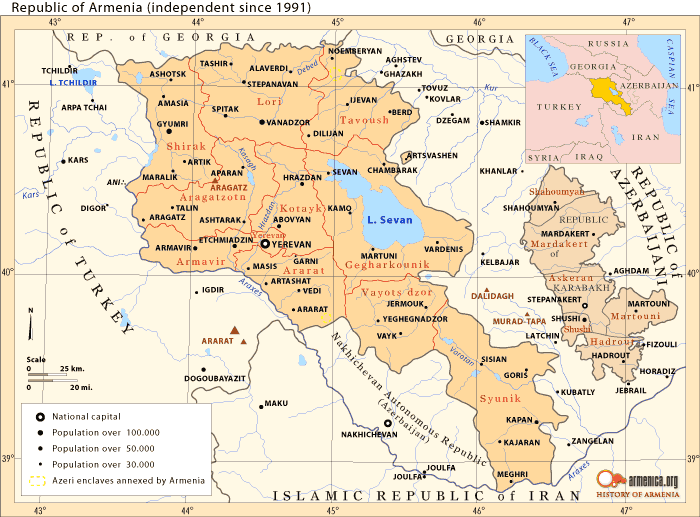
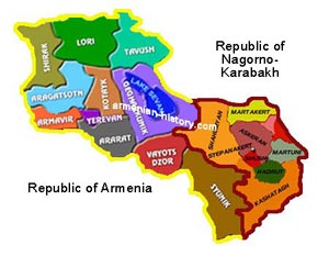
“Karabakh has one vital task- to achieve recognition of NKR’s independence within borders acceptable to the people of Karabakh, given that the priority of national security system is observed,” said Atanesyan. He emphasized that country borders acceptable for the people of Karabakh are stated in the NKR Constitution, which says that until recovering the territorial integrity of NKR its sovereignty applies to the factual territory of the republic. Recovery of territorial integrity of NKR implies return of the occupied Shahumyan region which, Atanesyan says, is a part of NKR.
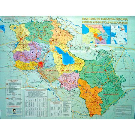
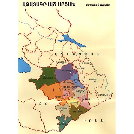
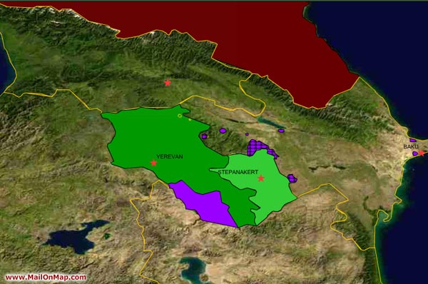
In 1991 NKR was declared on the territory of Soviet Autonomous Region of Nagorno Karabakh (ARNK) and Azerbaijan’s Shahumyan region. As a result of the 1991-94 war, the Shahumyan region and a number of lands belonging to the former ARNK passed to Azerbaijan and Armenian forces of Karabakh took 7 regions not included in former ARNK under their control. The NKR Constitution consolidates the current borders of NKR and that its territorial integrity has to be recovered.
NKR President Bako Sahakyan suggests that the definition “liberated lands” should be forgotten. In early November at his meeting with the residents of Kashatagh (former Lachin) and Shahumyan (former Kelbajar) regions the president said that the so called liberated territories are nothing more than lands consolidated by the NKR Constitution. Accordingly, an adequate perception of those lands has to be expected on the part of its residents, citizens of NKR.
The Kashatagh region is approximately as big as the former ARNK, and conditions there are deplorable, because whatever has been done during the post war period is not enough to overcome the desolation caused by the war.
“One of the main factors hindering the development of the region is the residents’ uncertainty concerning the region’s status,” President Sahakyan said. Uncertainty generates negative consequences, such as, the fact that the settlers are not in a hurry to acquire permanent addresses. “Don’t believe absurd rumors,” he said. “This is our country. And this is your land. They were liberated lands in early 90s. That’s history now. Our country has entered the stage of modern history. And for as long as Artsakh exists- and I can assure you it always will- this region will exist as well.”
A project for 2009 is under way aimed at the region’s social-economic development. Supposedly 5 billion drams ($165 million) will be allotted to that project (almost twice more than total allocations of all post-war years).
Opinions in Armenia are not unanimous in these terms. Even among radical opposition- the All-Armenian National Congress (ANC) lead by Levon Ter-Petrosyan - there isn’t a common opinion about the issue. As ANC coordinator Levon Zurabyan says, one part thinks that concessions are inevitable, the other that nobody is forcing Armenia to concede.
The most important thing, though, both in Armenia and in Karabakh is the recent speculations that the settlement of the issue is not around the corner, as Ter-Petrosyan and international mediators have been assuring. The opposition leader until now keeps saying that the Karabakh knot will be undone already this December. Mediators repeat the same thing saying that “the current level of mutual respect between the presidents of Armenia and Azebaijan” serves as a ground for hope that the main principles will soon be agreed upon.
Recent speculations in Azerbaijan over the need to amend their constitution are another proof that the parties are reaching an “accord” on settlement principles. As Azerbaijani political analyst Mubariz Akhmedoglu said in his interview to Day.az, “amendments concerning Karabakh” will soon be moved to the constitution. It can be assumed that amendments will be on the status of Karabakh , which, according to the constitution of Azerbaijan, is a part of their republic. On the other hand, the Armenian authorities assure that the issue won’t be settled so soon and that even after agreeing upon principles, a number of documents must be signed, discussed etc.
Most probably, everybody understands the word “outcome” in their own way. Those who are talking about impending settlement think that bringing the principles to an accord already means that the conflict is settled. The rest is mere technicality. To supporters of the “remote” settlement the outcome means signing a treaty of peace. And between those two “outcomes” is where Karabakhis live, understanding that agreeing on principles would mean loss of the security zone together with security itself. It is for that reason that they are wary of the current course of settlement.
Disputed territories: Karabakh insists on the country’s current area plus Shahumyan region

Karabakh’s silence in the highlight of the activated discussions on the Karabakh issue settlement is taken by many in Armenia as a sign of agreement with the Armenian authorities. However, Chairman of NKR Parliament Committee Vahram Atanesyan declared at his press conference held in Yerevan that there is an essential difference between Armenia’s approach and that of Karabakh.
Atanesyan stressed that Karabakh has its own approach to the settlement of the conflict, quite different from Armenia’s standpoint on the issue. One of the main differences, as Atanesyan said, is that NKR has only one priority and that is international recognition. The issue of lands and all discussions in this respect Karabakh considers irrelevant at this moment.
Karabakh insists on preserving its current boarders
“Karabakh has one vital task- to achieve recognition of NKR’s independence within borders acceptable to the people of Karabakh, given that the priority of national security system is observed,” said Atanesyan. He emphasized that country borders acceptable for the people of Karabakh are stated in the NKR Constitution, which says that until recovering the territorial integrity of NKR its sovereignty applies to the factual territory of the republic. Recovery of territorial integrity of NKR implies return of the occupied Shahumyan region which, Atanesyan says, is a part of NKR.
In 1991 NKR was declared on the territory of Soviet Autonomous Region of Nagorno Karabakh (ARNK) and Azerbaijan’s Shahumyan region. As a result of the 1991-94 war, the Shahumyan region and a number of lands belonging to the former ARNK passed to Azerbaijan and Armenian forces of Karabakh took 7 regions not included in former ARNK under their control. The NKR Constitution consolidates the current borders of NKR and that its territorial integrity has to be recovered.
NKR President Bako Sahakyan suggests that the definition “liberated lands” should be forgotten. In early November at his meeting with the residents of Kashatagh (former Lachin) and Shahumyan (former Kelbajar) regions the president said that the so called liberated territories are nothing more than lands consolidated by the NKR Constitution. Accordingly, an adequate perception of those lands has to be expected on the part of its residents, citizens of NKR.
The Kashatagh region is approximately as big as the former ARNK, and conditions there are deplorable, because whatever has been done during the post war period is not enough to overcome the desolation caused by the war.
“One of the main factors hindering the development of the region is the residents’ uncertainty concerning the region’s status,” President Sahakyan said. Uncertainty generates negative consequences, such as, the fact that the settlers are not in a hurry to acquire permanent addresses. “Don’t believe absurd rumors,” he said. “This is our country. And this is your land. They were liberated lands in early 90s. That’s history now. Our country has entered the stage of modern history. And for as long as Artsakh exists- and I can assure you it always will- this region will exist as well.”
A project for 2009 is under way aimed at the region’s social-economic development. Supposedly 5 billion drams ($165 million) will be allotted to that project (almost twice more than total allocations of all post-war years).
Opinions in Armenia are not unanimous in these terms. Even among radical opposition- the All-Armenian National Congress (ANC) lead by Levon Ter-Petrosyan - there isn’t a common opinion about the issue. As ANC coordinator Levon Zurabyan says, one part thinks that concessions are inevitable, the other that nobody is forcing Armenia to concede.
The most important thing, though, both in Armenia and in Karabakh is the recent speculations that the settlement of the issue is not around the corner, as Ter-Petrosyan and international mediators have been assuring. The opposition leader until now keeps saying that the Karabakh knot will be undone already this December. Mediators repeat the same thing saying that “the current level of mutual respect between the presidents of Armenia and Azebaijan” serves as a ground for hope that the main principles will soon be agreed upon.
Recent speculations in Azerbaijan over the need to amend their constitution are another proof that the parties are reaching an “accord” on settlement principles. As Azerbaijani political analyst Mubariz Akhmedoglu said in his interview to Day.az, “amendments concerning Karabakh” will soon be moved to the constitution. It can be assumed that amendments will be on the status of Karabakh , which, according to the constitution of Azerbaijan, is a part of their republic. On the other hand, the Armenian authorities assure that the issue won’t be settled so soon and that even after agreeing upon principles, a number of documents must be signed, discussed etc.
Most probably, everybody understands the word “outcome” in their own way. Those who are talking about impending settlement think that bringing the principles to an accord already means that the conflict is settled. The rest is mere technicality. To supporters of the “remote” settlement the outcome means signing a treaty of peace. And between those two “outcomes” is where Karabakhis live, understanding that agreeing on principles would mean loss of the security zone together with security itself. It is for that reason that they are wary of the current course of settlement.





Comment