If this is your first visit, be sure to
check out the FAQ by clicking the
link above. You may have to register
before you can post: click the register link above to proceed. To start viewing messages,
select the forum that you want to visit from the selection below.
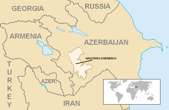
When we speak of N.K./Artsakh are we talking about all the area under Armenian control? or the just the province? and when the rest of the world talks about it what do they mean?
well there is the lernayeen and the tashdayeen, and in your map both are represented but even, still this map is incomplete and diffears from w wilson's which includes more territories from the artsakh side
Glad you asked this question so that we can settle this because a lot of people do not know what Artsakh was, is and what it will be. This post is for historic Artsakh.
Here is Artsakh from the 5th to 7th century, as part of one of the historic provinces of the Kingdom of Armenia.
As you can see, the historic province of Artsakh has most of the current borders of NKR highlited in your map + areas to the north that currently lie in "Azerbaijan" and parts of modern-day Armenia. If you're wondering, Utik and Kambechan are also historic Armenian provinces and Utik includes the city of Gandzak, now under baboon occupation and known as Ganja.
Here is Artsakh starting from the 9th century, now an Armenian Principality known as Khachen.
Here, parts of Utik and Artsakh have merged but Gandzak remains out. Note the word "Azerbaijan" that appears erroneously, it's there not because an "Azerbaijan" existed but because Iran has a historic province of Azarbaijan from which the fake republic got its name from. This Azarbaijan is way more south than the current fake republic.
Karabakh VS Nagorno-Karabakh VS Nagorno-Karabakh Republic
Karabakh, or Artsakh, is as Vasbourakan noted divided into two: Lernayin and Tashdayin.
Lernayin (Mountainous, Nagorny) is this:
This also corresponds to the Nagorno-Karabakh Autonomous Oblast (NKAO), a Stalin made fictional border/oblast that divided Karabakh from Armenia and its entirety and reduced it to an enclave and gained its "mountainous" title. Tashdayin is everything surrounding this "Nagorno-Karabakh" that once was under our control.
Nagorno-Karabakh Republic (NKR) is this:
As you can see, there is a northern branch. This is the occupied province of Shahumian and as witnessed in the previous maps, it was always historically Armenian. So basically, Nagorno-Karabakh Republic is all the lands we liberated during the war + occupied Shahumian.
Currently, what Artsakh is varies from person to person (UNFORTUNATELY).
-Some people refer to NKR as only the enclave of the NKAO and this is the position favored by the international community. Often I see Armenian-made maps showing these borders + Armenia as being the Armenian world only which disturbs me.
-For the NKR government, NKR is everything under their control + occupied Shahumian. This is the preferable position and is for what we should settle for... nothing less!
-Lately, a compromise border they are discussing is the former NKAO + Lachin corridor (where the highway that links Armenia with NKR is). So for some people, this is NKR.
Now that we know what Artsakh is, let's have a look at it from the inside.
---------------------------------------- Map of the provinces of the former NKAO:
Compare this with the following map which is NKR and its provinces. Each province is numbered. The areas with no stripes is Mountainous Artsakh. The areas with diagonal light-colored stripes are the liberated territories.The areas with horizontal dark-colored stripes are areas of Artsakh that remain under baboon occupation.
thanks a lot federate for all these lusapanutyun's, I learned a lot which ignored once, which makes me think that even in our schools courses are not very complete (unfortunately), however pls continue, we're all eager to learn more

 Tweet
Tweet


Comment