
Re: What are the N.K. borders?
thanks once again
there is not much about that so i appreciate it
-
Re: What are the N.K. borders?
NakhichevanOriginally posted by Ari View Post
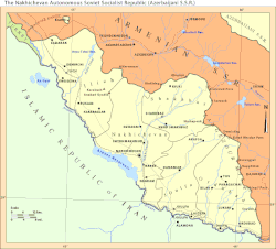
As the name suggests, its history lies within the Armenian nation and the new corrupted ("azerified") name so-called "Naxchivan" is simply a joke. The story of Nakhichevan is a tragic one, really. It's actually what prompted us to take Artsakh back before it was too late, before it became the next Nakhichevan.
To put it in a very brief way, the Armenian population of Nakhichevan has gone through some of the worse cleansings. Through time, the Armenians in Nakhichevan were de-populated by the Persians, Seljuks, Ottomans etc. For example, there is a town in Iran called New Julfa. The reason it's called this is because the Shah of Iran at the time forced Armenians to move out of Nakhichevan and settle in Persia and most of these Armenians were from the city of Julfa found in Nakhichevan (also where the Khachkars were savagely destroyed by the baboons 5 years ago). Eventually through the de-populations, manipulation of borders, settlement of rabbit-breeding "azeris" and so on, our population became a minority. The moment when it was officially handed over to the Azerbaboons was in the early 20s when the Bolsheviks gave it to them so they can please Ataturk's Turkey. Today there are ZERO Armenians in Nakhichevan.
Turkey today has a 9 km border with Nakhichevan which arguable presents the greatest threat to the survival of Armenia. Through that 9 km loophole, Turkey could invade Armenia through the Nakhichevan border, successfully bypassing the Russian agreement that only guards the Turkish-Armenian and Iranian-Armenian borders. More on this topic at a later date.
N.B. Just to add to the importance of having Nakhichevan back within our lands, Avarayr is located in Nakhichevan!
There are plenty of factors but I will give you the primary reason: the fake republic of "Azerbaijan" has a lot of this that some greedy bastards are hungry for:we cant get karabagh to be recognised by the world

EDIT: I have since learned that Avarayr actually currently lies in Iran. A shame Last edited by Federate; 01-22-2012, 05:42 PM.
Leave a comment:
-
Re: What are the N.K. borders?
so why is it that they have nakhitchevan and we cant get karabagh to be recognised by the worldLeave a comment:
-
Re: What are the N.K. borders?
From the Azerbaboonjan perspective
Nagorno-Karabakh Republic in babooni rayon terms
This post is to see what is under our control when taking into account the divisions/provinces (known as "rayons") of the baboon jungle.
A look into their rayons in NKR territory. All rayons are numbered but what interests us is the southwestern portion. Nagorno-Karabakh is in green and ALL divisions shown on this map corresponds to baboon divisions (even though some of them coincide with some of our divisions). Only thing to note is the broken-lined divisions found in 26 and 56 which is divisions NKR has done within itself.
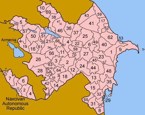
3. Agdam (Ağdam): Majority of rayon now within NKR. Divided into three parts with the northern portion in Martakert, central in Askeran and southern in Martuni.
14. Jabrayil (Cəbrayıl): Fully within NKR. Divided into two parts with the western portion in Kashatagh and eastern portion in Hadrut.
18. Fizuli (F�zuli): Roughly half of rayon within NKR. Incorporated into Hadrut.
26. Kalbajar (Kəlbəcər): Fully within NKR. Divided into two parts with the western portion in Shahumian and eastern in Martakert.
28. Lachin (La�ın): Fully within NKR. In Kashatagh.
42. Qubadli (Qubadlı): Fully within NKR. In Kashatagh.
54. Shusha (Şuşa): Fully within NKR. Remains its own province (Shushi).
55. Shusha city (Şuşa): Fully within NKR. Incorporated into Shushi province.
56. Tartar (Tərtər): Roughly half of rayon within NKR. In Martakert.
60. Khankendi city (Xankəndi): Fully within NKR. Remains its own province (Stepanakert) and capital of NKR.
63. Khojali (Xocalı): Fully within NKR. Remains its own province (Askeran).
64. Khojavend (Xocavənd): Majority within NKR. Divided into two province - Hadrut and Martuni.
** 21. Goranboy: Southern portion of rayon is claimed by NKR but remains under baboon control. Part of Shahumian province.Leave a comment:
-
Re: What are the N.K. borders?
yeah thanks a lot mate
good work with the maps
what you know about nakhitchevan?Leave a comment:
-
Re: What are the N.K. borders?
thanks a lot federate for all these lusapanutyun's, I learned a lot which ignored once, which makes me think that even in our schools courses are not very complete (unfortunately), however pls continue, we're all eager to learn moreLeave a comment:
-
Re: What are the N.K. borders?
Now that we know what Artsakh is, let's have a look at it from the inside.
----------------------------------------
Map of the provinces of the former NKAO:

Compare this with the following map which is NKR and its provinces. Each province is numbered. The areas with no stripes is Mountainous Artsakh. The areas with diagonal light-colored stripes are the liberated territories.The areas with horizontal dark-colored stripes are areas of Artsakh that remain under baboon occupation.

1. Shahumian
2. Mardakert
3. Askeran
4. Martuni
5. Hadrut
6. Shushi
7. KashataghLeave a comment:
-
Re: What are the N.K. borders?
thanks federate, now we can always use this thread to cite the situation with Artsakh's borders.Leave a comment:
-
Re: What are the N.K. borders?
Current Situation
Currently, what Artsakh is varies from person to person (UNFORTUNATELY).
-Some people refer to NKR as only the enclave of the NKAO and this is the position favored by the international community. Often I see Armenian-made maps showing these borders + Armenia as being the Armenian world only which disturbs me.
-For the NKR government, NKR is everything under their control + occupied Shahumian. This is the preferable position and is for what we should settle for... nothing less!
-Lately, a compromise border they are discussing is the former NKAO + Lachin corridor (where the highway that links Armenia with NKR is). So for some people, this is NKR.Leave a comment:
-
Re: What are the N.K. borders?
Artsakh after the Treaty of Sevres or the "Wilsonian Armenian" border:

Historic Artsakh is back within the Armenian borders.Leave a comment:
Leave a comment: