
Originally posted by Icy
View Post
-
Re: What are the borders of Nagorno-Karabakh?
No, there are no Armenians in Artsvashen. And if there are, they might all be Azerified. -
Re: What are the borders of Nagorno-Karabakh?
Are there any Armenian survivors left living there?Leave a comment:
-
Re: What are the borders of Nagorno-Karabakh?
Azerbaijan does. Check the map I posted, it is described as occupied territory of the RoA by Azerbaijan. They have renamed it to Bashkand .Originally posted by Icy View Post
More info here http://en.wikipedia.org/wiki/ArtsvashenLeave a comment:
-
Re: What are the borders of Nagorno-Karabakh?
Village of Artsvashen (Eagle's Nest) part of RA with its adjoining area. Before the 1930s it was actually connected to Armenia and was only made an enclave (like Artsakh) as Armenian land was transferred to Azerbaijan (see the Soviet administrative map of Armenian SSR from the late 1920s). Surrounded by Azeris and OMON forces, Artsvashen fell in late 1991 as the last battalion of Armenian freedom fighters there made sure all Armenian civilians were evacuated and fought to the last man.Originally posted by Icy View PostLeave a comment:
-
Re: What are the borders of Nagorno-Karabakh?
According to the map below (from semi-official source) Artsakh is divided into 9 regions (with Stepanakert, as the capital of Artsakh Republic, forming a separate administrative unit with a status of a region) and Karvachar separate from Shahumian region bringing it to total of 9 regions. The regional centers are underlined. I do believe the map is made sometime in 2007 or perhaps even 2008 so it would make it the most recent in relative terms, if the division (with respect to Karvachar and Shahumian being separate) are indeed so as of late 2009.
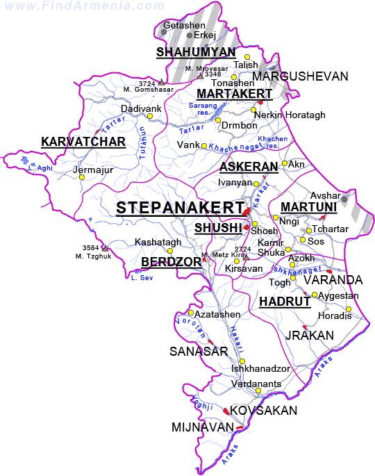
Leave a comment:
-
Re: What are the borders of Nagorno-Karabakh?
Originally posted by Siggie View Post
Stepanakert as a capital, just like Yerevan, has (or at least had as of 2006) a special administrative status and is (or perhaps was) counted as a separate political unit. I am not sure if this has been changed. Also it seems Karvachar (according to this division with Karvachar separate from Shahumian makes it 9 administrative divisions - however - for sake of accuracy we must confirm if Karvachar has certainly been made separate from (now Azeri occupied) northeastern parts of Shahumian (if still merged with Karvachar) and Stepanakert has been merged with Askeran region.

Provinces of Artsakh Republic: 1. Shahumyan; 2. Mardakert; 3. Askeran; 4. Martuni; 5. Hadrut; 6. Shushi; 7. Qashatagh. 8. Stepanakert.
Province Population (2006) Area (km2.)
Stepanakert 50,400 25.66
Askeran 17,000 1221.92
Hadrut 12,400 1876.80
Mardakert 18,900 1795.10
Martuni 23,100 951.20
Shahumyan 2,800 1829.80
Shushi 4,500 381.30
Qashatagh 8,600 3376.60Last edited by Catharsis; 11-10-2009, 06:54 PM.Leave a comment:
-
Re: What are the borders of Nagorno-Karabakh?
Very well done, much needed. Thank you Seth, Federate and Siggie.
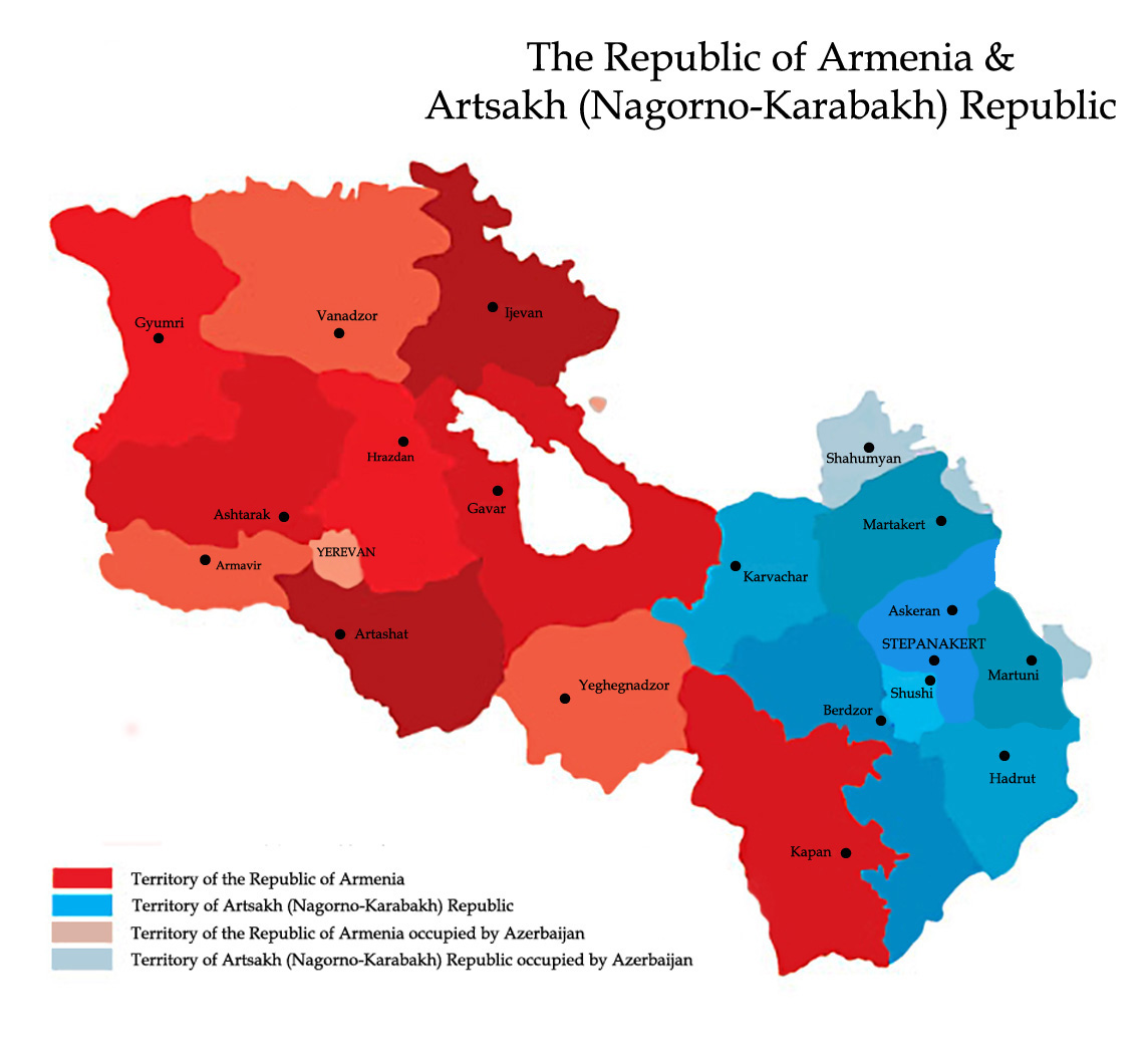
9 shrjans of Artsakh (Blue) + 11 marzes of RA (Red).Leave a comment:
Leave a comment: