If this is your first visit, be sure to
check out the FAQ by clicking the
link above. You may have to register
before you can post: click the register link above to proceed. To start viewing messages,
select the forum that you want to visit from the selection below.
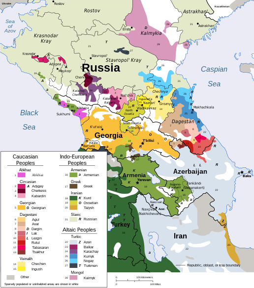
This is the least accurate and as Catharsis pointed out, is likely from the late 80s.
I believe the one posted by Federate is one of the most accurate, save perhaps for South Ossetia (specifically eastern parts which have also seen Georgian out-migration, as Ossetians have also fled other parts of Georgia).
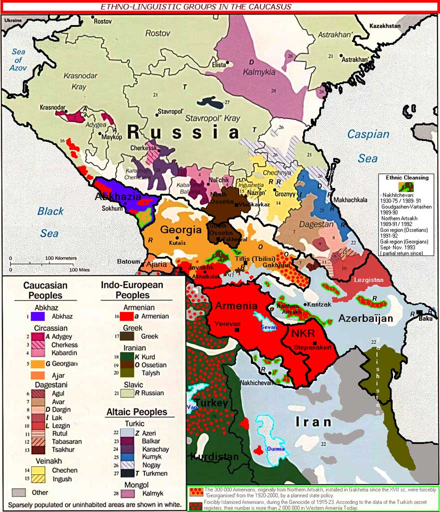
The one I posted is a good source of seeing how vast parts of historic Armenia have been ethnically cleansed (along with forcible conversions to Islam) of the native Armenian population.
As accurate as that map is at depicting the ethnographic composition of present day Armenia and the NKR it is somewhat misleading in pretty much all other regions. The below map should be more accurate. Although anyone foolish enough to think that clear and neat lines define ethnic groups should not even bother looking at any of these. These maps only provide a rough picture.
[/QUOTE]
This is the least accurate and as Catharsis pointed out, is likely from the late 80s.
Actually, this is the most accurate of the present situation. Map seems to pre-date last year's Georgian-Ossetian conflict since Georgians were thrown out of South Ossetia.
As accurate as that map is at depicting the ethnographic composition of present day Armenia and the NKR it is somewhat misleading in pretty much all other regions. The below map should be more accurate. Although anyone foolish enough to think that clear and neat lines define ethnic groups should not even bother looking at any of these. These maps only provide a rough picture.
Yes, however there have been wide demographic shifts (I believe the above map is based on 1989 demographics - the last population census held in the USSR at the end of every decade) in other conflicting parts of Caucasus such as Abkhazia and South Ossetia.
As accurate as that map is at depicting the ethnographic composition of present day Armenia and the NKR it is somewhat misleading in pretty much all other regions. The below map should be more accurate. Although anyone foolish enough to think that clear and neat lines define ethnic groups should not even bother looking at any of these. These maps only provide a rough picture.
It is a Russian derived word - Нагорный - Nagorniy (or Nagornii) meaning mountainous since when the 'Nagorno-Karabakh Autonomous Oblast' was created in 1923 there was a Mountainous or Highland Karabakh and also Lowland (or Valley) Karabakh. The 'Lowland Karabakh' included territories that were to the north of NKAO and the word was well in circulation until the 1960s. The Armenians of 'Lowland Karabakh' (towns and villages in the regions all around the city of Gandzak - including Martunashen, Tchragidzor, Shamkor, K'arhat, Shahumyan etc.) were deported between 1988-1991. With some of the fiercest battles taking place for Armenian villages and towns like Getashen, Martunashen and Shahumian in the Shahumian region of Artsakh that to this day is still occupied by Azeri forces along with parts of northeastern Martakert and eastern Martuni regions of the Republic of Artsakh.
I agree, Artsakh is a far better name then the russian word which is more of a description then a name.
Yes, Artsakh (13th province of Greater Armenia) is mentioned in Vanic - Araratian inscriptions as Ardakh. Strabo mentions it in the First Century BC as an Armenian province (Orxistine) that was renowned for its strong cavalry. Khorenatsi - the Fifth Century Father of Armenian History notes that it was ruled by the House of Sisak (closely associated with the neighboring Syunik-Sisakan province), from the bloodline of patriarch Hayk.
Artsakh along with Utik and Paytakaran provinces of Greater Armenia was also called - Առան - Aran.


Leave a comment: